The role of geography in the Muslim civilization
The years of the Abbasid rule have made history due to the heyday of the Islamic civilization. It is well known that Caliphs ordered road reports from specialists in order to help their postmen deliver messages as quickly and accurately as possible to recipients within the territory of their own empire. That information, which initially resulted in the “Book of Routes”, laid the foundation for a more intensive collection of information about distant places and foreign lands, which comprised not only geographical peculiarities but also production capacity and commercial component. With the development of more precise astronomy and mathematics, mapping became one of the leading branches of science.
Geography became an important field of study, especially with the dissemination to the general public of the works by Al-Khwarizmi, one of the earliest geographers and a very talented mathematician. His famous book “The Image of the Earth” inspired a generation of writers in Baghdad and Muslim Spain (Al-Andalus). This work became the main source of inspiration for numerous excavations, further analysis and recording of previously obtained and known geographical data among a generation of scholars from both Muslim and the rests of the world.
Muslim maps that have changed our world view
Speaking of geography, it is impossible not to pay attention to the top-10 maps of Muslim scientists, among which there is one of the earliest known maps of South America and the map where the world seems upside down! The time when the North was the South and the South was the North, towards Mecca…
Every year, as more and more people began travelling around the world for commercial, research and religious reasons, the demand for good, quality and accurate maps was increasing. Some of the most valuable world maps were made by scientists, geographers and navigators, who gathered the geographic knowledge they knew, conducted detailed mathematical analysis, measured and mapped the Earth's features, and used sophisticated astrolabes to help estimate altitude and distance. And today we will introduce you to some of these priceless examples.
Ali Makar’s map, XVI century
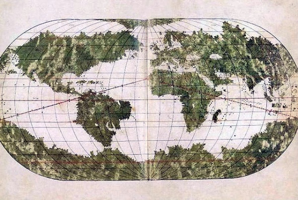
Photo: alfarabinur.kz
The “Atlas of Ali Makar” is today in the library of the Topkapi Palace, which is located in Istanbul. As a work of art, this atlas is certainly one of the most successful. It contains six portolan charts and one mappa mundi map. It is all made in double pages, which is a total of fourteen pages. They are drawn on parchment sheets and bound in leather, forming a small handy book.
The cartographer, who drew those maps, must have been professionally connected to those who drew similar maps in Christian Europe. This proves the artistic perfection of the atlas, which excludes imitation and suggests that the author should have been a master with extensive experience in this kind of work.
Al-Istakhri’s map, X century
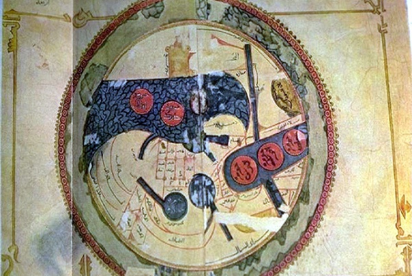
Photo: alfarabinur.kz
On the Abul Qasim Ubaidullah ibn Abdullah ibn Khurdad-Bih al Istakhri (934 AD)’s world map, the South is in the top, as was common of maps at the time. The picture is displayed on “old manuscripts and maps from Khorasan”. It was believed that Istakhri created the earliest known description of windmills. His works in the Arabic language included such works as “Traditions of Countries” and “Shapes of the Climes”.
Tarih-I-Hindi Garbi’s map, XVI century
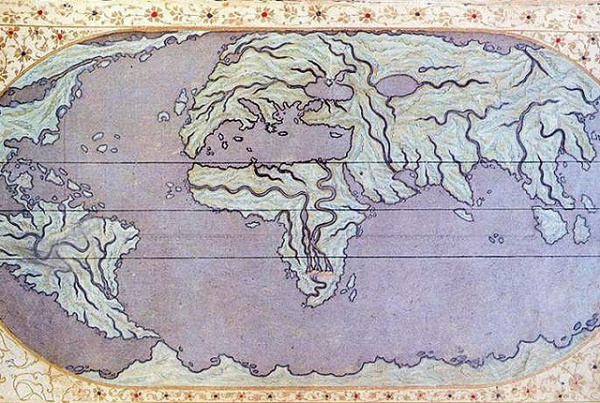
Photo: alfarabinur.kz
The book entitled “History of the West Indies” probably written by Muhammad b. Amir al-Suudi al-Niksari (d. 1591) in the XVI century, contains rather detailed and interesting information about geographical discoveries and the New World (America). This work, based on the Spanish and Italian geographical sources, was presented to Sultan Murad III in 1573.
The book tells the amazing stories of the explorations and conquests of Columbus, Cortes, Pizzaro and other seamen and travelers, and it also endeavors to incorporate the new geographic information into the body of Islamic knowledge. The work is a serious and unique attempt of the Ottoman Muslim scholar not only to transmit the information from one culture (European Christianity) to another (Islam) through the translation, but also to correct and expand Islamic geography and cartography.
Ibn Hawqal’s map, X century
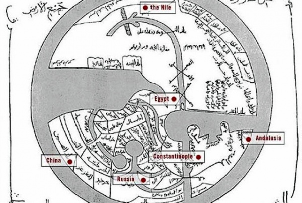
Photo: alfarabinur.kz
The map (here the South is also in the top) was prepared by the widely travelled Abu al-Qasim Muhammad b. Hawqal, originally from Al-Jazira region in Turkey, north of Mardin. He is also called Al-Nusaybini, after Nusaybin town located in this region.
Unfortunately, there is very little information about Ibn Hawqal. However, he is believed to be a Baghdad trader who loved travelling very much. Researchers attribute the dearth of information about Ibn Hawqal to the fact that he spent a substantial part of his life in travelling and that he rarely stayed in a certain region for a long time. His book “Surat al-Ard” gives a chance to get acquainted with the author a bit closer and at least to find out that he enjoyed reading, especially books by Khurdadhebah, Qudadmah and al-Jihani, which might have been the reason behind his keenness to travel and see the places he read about.
Katip Çelebi’s map, XVI century
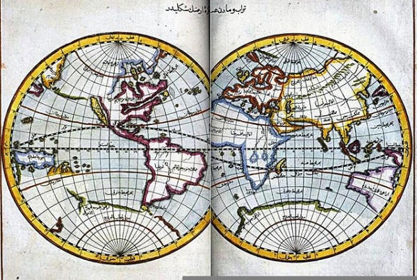
Photo: alfarabinur.kz
“The Gift to the Great Ones on Naval Campaigns” was written by Katip Çelebi in 1657 and emphasizes the importance of the Turkish activities in the seas and the Ottoman contribution to the navigation establishment.
In his works, Katip Çelebi often drew attention to the necessity to study the science of geography and explained that the rulers of the state had to know the borders of the Ottoman State and the states in that region, even if they did not know the whole of the Earth.
Çelebi appreciated history as much as we do now and asserted the most of people did not know the value of this branch of knowledge and thus viewed history as a fairy tale. He expressed his complaint with one phrase: “Who reads and listens to a letter of love and faithfulness?”
Al-Balkhi’s map, IX century
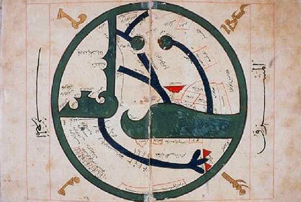
Photo: alfarabinur.kz
It is impossible not to mention the map by Abu Zaid Ahmed ibn Sahl al-Balkhi (850-934), a Persian geographer who was a disciple of al-Kindi and also the founder of the “Balkhi School” of terrestrial mapping in Baghdad. The picture is displayed on “old manuscripts and maps from Khorasan”.
Mahmud of Kashgar’s map, XI century
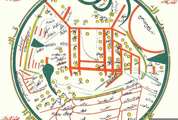
Photo: alfarabinur.kz
Mahmud of Kashgar completed his famous book “Divânu Lügati't-Türk” in 1074. Famous in the world for being a linguist, he wrote that book in order to teach Arab speakers Turkish and prove that the Turkish language was as important as the Arabic.
In that book Mahmud stated that the regions of all the Turkish tribes from Europe to China were included in full detail within a circular map, which, as he pointed, was drawn in order to show the regions the Turks inhabited. The East, the West, the North and the South, as well as some seas and rivers were also indicated on the map. The places shown in the West stretched all the way to Atil, where kipchaks and franks lived. In the southwest of Ethiopia, in the south India, in the east of China and Japan, Turkish cities were marked, while in the center – Yarkent, Kashgar, Barsgar, Balasagun, Ifruk, Ikiokuz, Asbuali, Kumri, Talas.
The western, northern and southern parts of Asia remained undrawn but despite the fact that the map was full of factual errors, the data about the eastern regions were completely correct. Mahmud indicated the Great Wall of China on his map and mentioned that the wall and high mountains acted as natural obstacles preventing him from learning the Chinese language. He also claimed that Japan shared the same fate, being an island in the eastern part of Asia.
As it was mentioned previously, the first Japanese map was drawn in the XIV century and it was included for the first time in a world atlas in the XV century. However, when the information given above is taken into consideration, one can say that the first map of Japan, although it had many errors and was just crude drawing, was drawn by Mahmud of Kashgar in the XI century.
“The Book of Curiosities” map, XI century
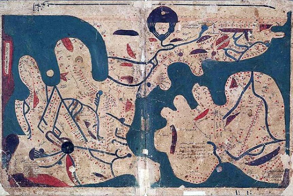
Photo: alfarabinur.kz
The Bodleian library at the University of Oxford has purchased the medieval Arabic manuscript Kitab Gharaib al-Funun Wa-Mulah Al-Uyu popularized under the title “The Book of Curiosities”. This treatise is an exceptionally rich text on cosmography and one of the most important recent finds in the history of Islamic cartography in particular, and for the history of cartography in general.
This manuscript is a highly illustrated treatise on astronomy and geography, compiled by an unknown author between 1020 and 1050, which contains an important and hitherto unknown series of colorful maps, giving unique insight into Islamic concepts of the world. The copy owned by the Bodleian library is the only nearly complete copy that has been extensively studied and published in an electronic edition.
Piri Reis’s map, XVI century
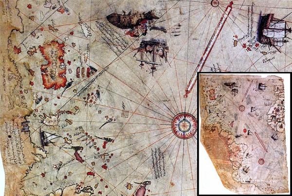
Photo: alfarabinur.kz
Piri Reis is a well-known Ottoman-Turkish admiral, geographer and cartographer of the XVI century. Piri Reis is primarily known nowadays for his world maps and charts collected in his Kitab-i-Bahriye (“The Book of Navigation”). But since their discovery, his two world maps have aroused a special interest, which continues to grow both in popular culture and scholarly circles. Unfortunately, they are only partially extant. A fragment of the first world map prepared in 1513, was discovered in 1929 at the Topkapi Palace in Istanbul. It is signed by Piri Reis and dated Muharram 919 (9 March-7 April 1513). It is only part of the world map which the author presented to Sultan Selim I in Cairo in 1517.
The most surprising aspect was the presence of America on the Ottoman map. This is the most ancient of all known Turkish charts showing the New World, and one of the most ancient charts of America still in existence in the world.
The map of the year 1513 was based on approximately 20 older maps which Piri Reis had collected, including charts personally designed by Christopher Columbus which his uncle Kemal Reis had obtained in 1501 after capturing seven Spanish ships off the coast of Valencia in Spain with several members of Columbus’s crewmen on board.
The brightest feature of this map is the level of accuracy in the positioning of the continents (especially the relationship between Africa and South America) which was unparalleled for its time. Even maps drawn decades later did not have such accurate positioning and proportions.
The surviving fragment of the first world map of Piri Reis drawn in 1513 is the oldest known map which includes the continent of America. The map shows part of Europe and west coast of Africa, eastern, central and south America, the Atlantic islands and the ocean. A great deal of detail is given of South America.
Piri Reis’s world map shows the Atlantic with the adjacent coasts of Europe, Africa and the New World. The second one, dating from 1529-29, of which about one sixth has survived, covers the north western part of the Atlantic including the southern tip of Greenland, North America from Labrador and Newfoundland in the north to Florida, Cuba and some parts of Central America.
The German scholar Paul Kahle made a thorough analysis and description of Piri Reis’s maps. He observed that Piri Reis was an excellent and reliable cartographer. Kahle also points out that the whole picture of Columbus has been distorted, as almost all the important documents related to him, and in particular his ship’s journal, have been preserved not in their original but in abstracts and edited works, mostly by Bishop Las Casas.
Long after Kahle, in the middle of the 1960s, Hapgood returned to the subject of the Topkapi map. Amazed by the richness of the map, he attributed it to an advanced civilization dating from the Ice Age. On the basis of Piri Reis’s maps, Charles Hapgood argued that these maps preserved knowledge of unknown civilizations.
Al-Idrisi’s “World Upside Down” map, XII century
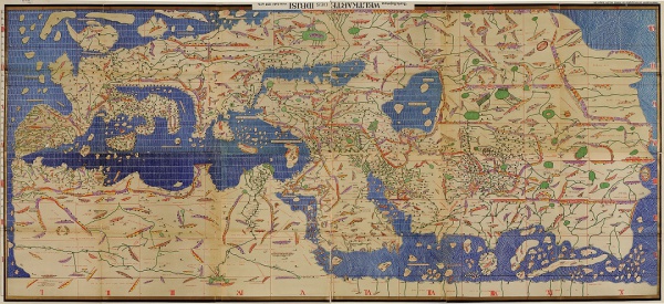
Photo: alfarabinur.kz This map has been rotated to show its resemblance to modern maps.
This is probably one of the most famous maps from Muslim Civilization. It was drawn by Muhammad Al-Idrisi, who was born in Ceuta (Morocco) in 1099-1100 AD and died in 1166 AD. The map is oriented with South at the top as was common at the time – we have mentioned it before.
Al-Idrisi studied at Cordoba. However, he spent his working life at the Norman court of Palermo. At the age of 16 he was travelling through Asia Minor, Morocco, Spain and the South of France and he even visited England. His description of most of Western Europe turned out to be quite accurate and vivid. The same is true of his treatment of the Balkans, while for the rest of Europe and for most of the Islamic World (with the exception of North Africa, with which he had a firsthand acquaintance) his account is based on the writings of others.
Al-Idrisi was an excellent and original geographer. He creatively used the system of cylindrical projection of the Earth’s surface, which was to be claimed some centuries later, in 1569, by the Flemish Gerard Mercator. Al-Idrisi’s other merit, according to specialists, is the extensive information he provides about contemporary Western Europe. For instance, Al-Idrisi’s map places the sources of the Nile – supposedly discovered in the second part of the XIX century in the equatorial highlands of Africa.
Ibn al-Wardi’s maps
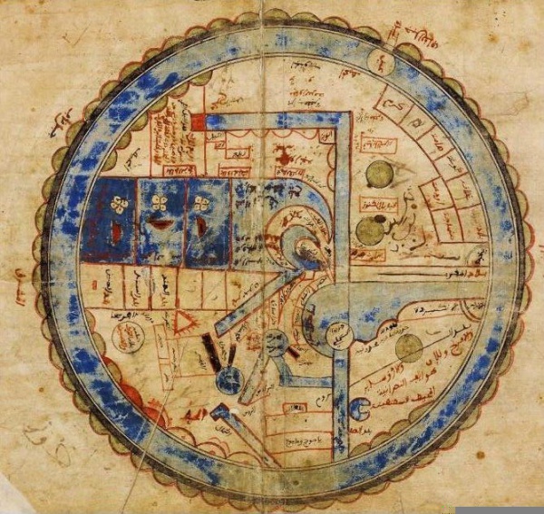
Photo: alfarabinur.kz
Al-Wardi used a colored picture of Kaaba in his maps. In his works, he summed the geographical knowledge of the Arab world of the time, referring to climate, terrain, fauna and flora, population, lifestyle, existing states and their governments in individual regions of the world. The author also paid a special attention to the description of Slavs and their way of living and mentioned al-Mahdiyya as the residence of the Fatimid dynasty. Therefore, the book is older than the city of Kairo (founded in 698 AD). Al-Wardi makes reference in his book to the book by Al-Masudi.
Matrakci’s beautiful maps
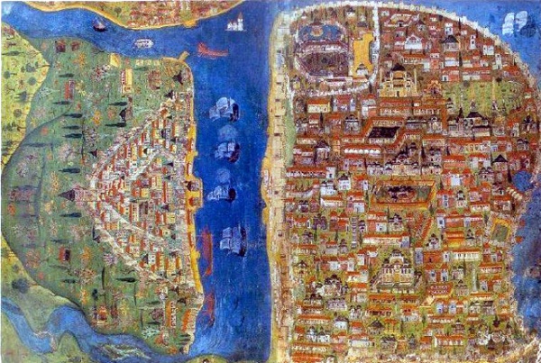
Photo: quran-sunna.ru
Matrakci Nasuh was a famous Ottoman polymath, writer and knight who produced important books in various branches of knowledge. He made a contribution to such sciences as mathematics, geography, history and calligraphy. He also invented a military lawn game called “Matrak”, a kind of animation of battle.
Matrakci was an important figure in the field of descriptive geography. His first book “Bayan-I Manazil Safar Iraqayn” (dedication to the expeditions to Iraq) was written in the Turkish language. And his miniatures showing roads connecting Istanbul, Tabriz and Baghdad are similar to maps. His history of the 1534-1536 travels to Iran and Iraq includes a double folio depicting Istanbul with all modern structures of the city shown in remarkable detail. For a long time Matrakci’s map became a major document for the study of Istanbul in the 1530s. In addition to it, it was Nasuh who initiated the topographic genre of painting.
Researchers and geographers compare Matrakci’s land maps with Piri Reis’s Portland maritime maps, which one can find in his Kitab-i-Bahriye. Two other Matrakci’s works containing miniatures are especially important from a geographical perspective. In one of them there were drawn the inns between Istanbul and Budapest, as well as the cities of Nice, Toulon and Marseilles during Barbaros’s visits and the Ottoman fleet.
Being a member of the administration, Nasuh accompanied Suleiman the Magnificent on various campaigns and carefully recorded the events and illustrated the cities and ports conquered by the Ottomans. He took part in the Mohac campaign (1526) and the two Baghdad expeditions of Kanuni. He illuminated the picture of every city where the army was billeted or passed by. Turkish History Institution published the city paintings he made during the expedition.
There are many other names that contributed to the geography field from the Muslim Civilization to the Modern World. This is only a small part of them:
1. Al-Razi compiled a basic geography of the Iberian Peninsula;
2. Mohammed Ibn Yousef Al-Warraq committed to paper the topography of North Africa;
3. Al-Bakri was an outstanding scholar and litterateur, wrote an important geographical work devoted to the Arabian Peninsula and the names of various places;
4. Ibn Baitar from Malaga was driven by his genuine interest in pharmaceutical herbs and flowers in order to explore every corner of the Iberian Peninsula and Maghreb (Morocco);
5. Ibn Khaldun, a Tunisian adventurer, university professor and diplomat, is famous for his works on sociology, economics, history, philosophy, political science and anthropology;
6. Ahmad ibn Majid, a poet and navigator, is also famous for assisting Vasco da Gama in his quest of South Africa, as well as for his book of useful information on the principles and rules of navigation.
This list can be continued indefinitely and added to with such names as Ibn Battuta, Ahmad ibn Fadlan, Ibn Jubair, Zheng He, Miskawayh, Ibn Rustah, Al-Tartushi, Ahmad al-Yaqubi, Ibn Qutiya, al-Maqqari, Ibn al-Athir, Yaqut al-Hamawi, Abu al-Fidaand, ibn Abi Bakr al-Zuhari.
Ilmira Gafiyatullina
Photo in the slider: arielmore/Pixabay
